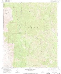
1972 Map of Bassett Peak
USGS Topo · Published 1975About this map
The Galiuro Mountains dominate this 1970s topographic study, showcasing a high-altitude wilderness within the Coronado National Forest. Centered on the towering Bassett Peak, the map reveals a landscape defined by sharp elevation changes and numerous natural water sources including Mott Spring and Echols Spring. The presence of the Powers Mine and Long Tom Mine suggests a history of small-scale mineral exploration tucked away in these high ridges, accessible only by a network of primitive routes like the Rattlesnake Pack Trail.
Find a feature on this map
56 named features on this map. Tap any name to fly to it.
Don’t see what you’re looking for? This feature index may not catch every label — zoom into the map to look around manually.
Map Details
Editions of this 1972 Bassett Peak Map
2 editions found
Other maps of this area

1938 · Galiuro Mts
USGS Topo · 1:48,000

1940 · Sierra Bonita Ranch
USGS Topo · 1:62,500

1942 · Sierra Bonita Ranch
USGS Topo · 1:62,500

1943 · Galiuro Mts
USGS Topo · 1:62,500

1943 · Sierra Bonita Ranch
USGS Topo · 1:62,500

1943 · Winchester Mts.
USGS Topo · 1:62,500

1945 · Redington
USGS Topo · 1:62,500

1945 · Winchester Mts.
USGS Topo · 1:62,500

1956 · Tucson
USGS Topo · 1:250,000

1957 · Redington
USGS Topo · 1:62,500