2023 Map of Bayville
USGS Topo · Published 2023About this map
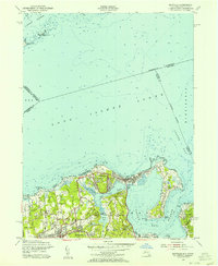
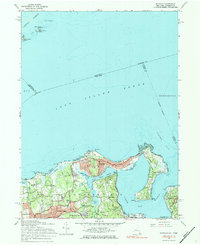
Sagamore Hill National Historic Site anchors the eastern edge of this coastal survey, preserving the residential landscape of the Gold Coast era. The peninsula-rich shoreline is dominated by the Oyster Bay National Wildlife Refuge, which protects the salt marshes and waters of Mill Neck Creek and West Harbor. Inland, the map reveals a pattern of established estates and small villages including Lattingtown, Matinecock, and Locust Valley. Numerous small family and community burial grounds, such as Underhill Cem, Locust Valley Cem, and Pratt Cem, are interspersed among the residential areas and wooded patches like Shu Swamp. The map details the complex geography of Long Island Sound and its various points, such as Oak Neck Point and Peacock Point, illustrating how the marine environment has shaped the development of these Nassau County communities.
Find a feature on this map
109 named features on this map. Tap any name to fly to it.
Don’t see what you’re looking for? This feature index may not catch every label — zoom into the map to look around manually.
Map Details
Editions of this 2023 Bayville Map
This is the sole edition of this map. No revisions or reprints were ever made.
Historical Maps of Oyster Bay Through Time
3 maps found