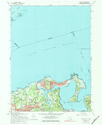
1967 Map of Bayville
USGS Topo · Published 1984About this map
The northern coast of Long Island meets the Long Island Sound along a complex shoreline of peninsulas and sheltered harbors. In this mid-century landscape, the village of Bayville occupies a narrow strip of land between Oak Neck Creek and the sound, connected to the mainland near Mill Neck. The area is defined by established estates and institutions, including the St Josephs Monastery and the Sagamore Hill Nat Historical Site on the eastern edge of the quadrangle.
Find a feature on this map
62 named features on this map. Tap any name to fly to it.
Don’t see what you’re looking for? This feature index may not catch every label — zoom into the map to look around manually.
Map Details
Editions of this 1967 Bayville Map
Other maps of this area

1892 · Stamford
USGS Topo · 1:62,500

1892 · Norwalk
USGS Topo · 1:62,500

1893 · Stamford
USGS Topo · 1:62,500

1893 · Norwalk
USGS Topo · 1:62,500

1897 · Oyster Bay
USGS Topo · 1:62,500

1898 · Oyster Bay
USGS Topo · 1:62,500

1899 · Stamford
USGS Topo · 1:62,500

1900 · Oyster Bay
USGS Topo · 1:62,500

1901 · Northport
USGS Topo · 1:62,500

1903 · Northport
USGS Topo · 1:62,500