
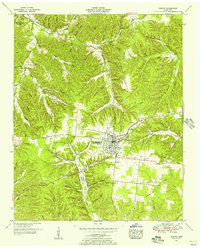
1936 Map of Beaverdam Springs
USGS Topo · Published 1936About this map
Beaverdam Springs and the surrounding Tennessee hill country appear here during the mid-1930s, showing a landscape defined by deep hollows and narrow ridge-top roads. Small settlements and crossroads serve as the focal points for rural life, including Wadesville and Hornertown, the latter featuring a notable Hornertown Observation Tower along State Highway No 100. This area is heavily dissected by watercourses like Sulphur Fork and Beaverdam Creek, which dictated the placement of early schools and family cemeteries such as Springer Cem and Chandler Cem.
Find a feature on this map
63 named features on this map. Tap any name to fly to it.
Don’t see what you’re looking for? This feature index may not catch every label — zoom into the map to look around manually.
Map Details
Editions of this 1936 Beaverdam Springs Map
This is the sole edition of this map. No revisions or reprints were ever made.
Other maps of this area

1901 · Colombia
USGS Topo · 1:125,000

1936 · Graves Spring
USGS Topo · 1:24,000

1936 · Pleasantville
USGS Topo · 1:24,000

1936 · Coble
USGS Topo · 1:24,000

1936 · Nunnelly
USGS Topo · 1:24,000

1936 · Whitfield
USGS Topo · 1:24,000

1936 · Sunrise
USGS Topo · 1:24,000

1936 · Kimmins
USGS Topo · 1:24,000

1936 · Gordonsburg
USGS Topo · 1:24,000
1951 · Kimmins
USGS Topo · 1:24,000