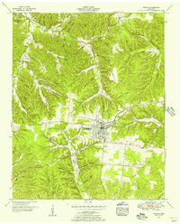
1951 Map of Kimmins
USGS Topo · Published 1956About this map
Hohenwald serves as the central hub of this mid-century landscape, positioned at a significant transportation junction in Lewis County. The town is defined by a grid of streets and the Nashville Chattanooga and St Louis railway, which reaches into the timbered hills of the Highland Rim. The map records a transition in transit, documenting a dismantled railroad line branching away from the main tracks, while the County Airport and several local pumping stations point toward modern utility and infrastructure development.
Find a feature on this map
77 named features on this map. Tap any name to fly to it.
Don’t see what you’re looking for? This feature index may not catch every label — zoom into the map to look around manually.
Map Details
Editions of this 1951 Kimmins Map
3 editions found
Other maps of this area

1901 · Colombia
USGS Topo · 1:125,000

1905 · Waynesboro
USGS Topo · 1:125,000

1936 · Riverside
USGS Topo · 1:24,000

1936 · Graves Spring
USGS Topo · 1:24,000

1936 · Pleasantville
USGS Topo · 1:24,000

1936 · Beaverdam Springs
USGS Topo · 1:24,000

1936 · Henryville
USGS Topo · 1:24,000

1936 · Sunrise
USGS Topo · 1:24,000

1936 · Kimmins
USGS Topo · 1:24,000

1936 · Topsy
USGS Topo · 1:24,000