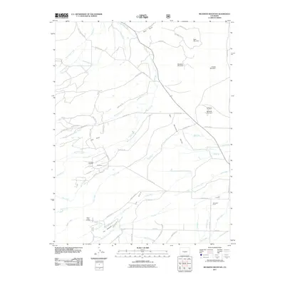
2011 Map of Beckwith Mountain
USGS Topo · Published 2011About this map
Wet Mountain Valley dominates this 2011 survey, revealing a landscape defined by ranching and an intricate water management system. The high-altitude terrain is marked by prominent peaks such as Beckwith Mountain, Buck Mountain, and Beddows Mountain, which overlook a network of seasonal and permanent watercourses. A complex infrastructure of irrigation channels, including the Ula Ditch, Hogback Ditch, and the Freer-Beckwith and Kennicott Ditch, underscores the agricultural importance of the prairie lands. Settled areas like The Pines and the San Isabel Ranch are supported by these water systems, while the Phares and Allen Mine serves as a reminder of the area's extraction history. Local genealogy is preserved at the Pines Cemetery and Ula Cemetery, providing clear points of reference for researchers tracing families in this part of Custer County.
Find a feature on this map
73 named features on this map. Tap any name to fly to it.
Don’t see what you’re looking for? This feature index may not catch every label — zoom into the map to look around manually.
Map Details
Editions of this 2011 Beckwith Mountain Map
This is the sole edition of this map. No revisions or reprints were ever made.
Other maps of this area

1889 · Canon City
USGS Topo · 1:125,000

1892 · Canon City
USGS Topo · 1:125,000

1954 · Pueblo
USGS Topo · 1:250,000

1955 · Westcliffe
USGS Topo · 1:24,000

1957 · Pueblo
USGS Topo · 1:250,000

1957 · Aldrich Gulch
USGS Topo · 1:24,000

1958 · Pueblo
USGS Topo · 1:250,000

1958 · Beckwith Mountain
USGS Topo · 1:24,000

1959 · Electric Peak
USGS Topo · 1:62,500
1959 · Horn Peak
USGS Topo · 1:24,000