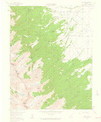
1959 Map of Horn Peak
USGS Topo · Published 1961About this map
The Sangre de Cristo Range forms a dramatic western spine on this 1959 survey, where the high peaks of Mount Adams and Horn Peak define the boundary between Custer and Saguache counties. The transition from the high-altitude wilderness of the San Isabel National Forest to the pastoral drainage of the Wet Mountain Valley is visible through a complex network of glacial features and mountain streams. High lakes such as Comanche Lake and Goodwin Lakes feed into various branches of Taylor Creek and Cottonwood Creek. Human presence is concentrated on the lower slopes, where Tanglewood Acres and Horn Creek Ranch are situated near the edge of the forest. The Rainbow Trail runs parallel to the base of the mountains, acting as a historical conduit for travel through this rugged stretch of central Colorado.
Find a feature on this map
56 named features on this map. Tap any name to fly to it.
Don’t see what you’re looking for? This feature index may not catch every label — zoom into the map to look around manually.
Map Details
Editions of this 1959 Horn Peak Map
4 editions found
Other maps of this area

1889 · Canon City
USGS Topo · 1:125,000

1889 · Huerfano Park
USGS Topo · 1:125,000

1892 · Huerfano Park
USGS Topo · 1:125,000

1892 · Canon City
USGS Topo · 1:125,000

1954 · Trinidad
USGS Topo · 1:250,000

1954 · Pueblo
USGS Topo · 1:250,000

1955 · Westcliffe
USGS Topo · 1:24,000

1955 · Trinidad
USGS Topo · 1:250,000

1957 · Pueblo
USGS Topo · 1:250,000

1957 · Aldrich Gulch
USGS Topo · 1:24,000