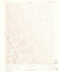
1959 Map of Horn Peak
USGS Topo · Published 1966About this map
The San Isabel National Forest and Rio Grande National Forest meet along the high Sangre de Cristo divide, where the Custer Co Saguache Co line separates the dramatic peaks from the lower Valley. This 1959 survey shows a landscape defined by high-altitude drainage systems, with numerous creeks like Goodwin Creek, Venable Creek, and Cottonwood Creek flowing eastward toward Reiser Prairie. Small pockets of human activity are clustered near the forest edge, including Abbots Lodge, Horn Creek Ranch, and Tanglewood Acres. For those studying the recreational history of the era, the map meticulously tracks several major backcountry routes, most notably the long Rainbow Trail and the Venable Comanche Trail, which connect the high lakes and peaks like Horn Peak and Mount Adams to the lower homesteads and picnic grounds such as Alvarado Picnic Ground.
Find a feature on this map
50 named features on this map. Tap any name to fly to it.
Don’t see what you’re looking for? This feature index may not catch every label — zoom into the map to look around manually.
Map Details
Editions of this 1959 Horn Peak Map
4 editions found
Other maps of this area

1889 · Canon City
USGS Topo · 1:125,000

1889 · Huerfano Park
USGS Topo · 1:125,000

1892 · Huerfano Park
USGS Topo · 1:125,000

1892 · Canon City
USGS Topo · 1:125,000

1954 · Trinidad
USGS Topo · 1:250,000

1954 · Pueblo
USGS Topo · 1:250,000

1955 · Westcliffe
USGS Topo · 1:24,000

1955 · Trinidad
USGS Topo · 1:250,000

1957 · Pueblo
USGS Topo · 1:250,000

1957 · Aldrich Gulch
USGS Topo · 1:24,000