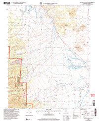
2001 Map of Beckwith Mountain
USGS Topo · Published 2005About this map
Wet Mountain Valley dominates this high-altitude Custer County landscape, where the transition from the Prairie floor to the high peaks of the Sangre De Cristo Wilderness is clearly defined. Small settlements and family holdings like The Pines and San Isabel Ranch are scattered across the terrain, reflecting the area's ranching roots. The map reveals an intricate network of water management essential for this arid environment, featuring numerous irrigation works such as the Lohstron Highline Ditch, Kick and Kint Ditch, and James Jarvis Swift Creek Ditch No 3. These human-made channels intersect natural watercourses like Texas Creek and Taylor Creek, while the Rainbow Trail skirts the forest boundary. Local genealogy and history are preserved at sites like The Pines Cem and Ula Cem, marking the early communities that settled at the foot of Beckwith Mountain.
Find a feature on this map
57 named features on this map. Tap any name to fly to it.
Don’t see what you’re looking for? This feature index may not catch every label — zoom into the map to look around manually.
Map Details
Editions of this 2001 Beckwith Mountain Map
This is the sole edition of this map. No revisions or reprints were ever made.
Other maps of this area

1889 · Canon City
USGS Topo · 1:125,000

1892 · Canon City
USGS Topo · 1:125,000

1954 · Pueblo
USGS Topo · 1:250,000

1955 · Westcliffe
USGS Topo · 1:24,000

1957 · Pueblo
USGS Topo · 1:250,000

1957 · Aldrich Gulch
USGS Topo · 1:24,000

1958 · Pueblo
USGS Topo · 1:250,000

1958 · Beckwith Mountain
USGS Topo · 1:24,000

1959 · Electric Peak
USGS Topo · 1:62,500
1959 · Horn Peak
USGS Topo · 1:24,000