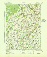
1943 Map of Bedminster
USGS Topo · Published 1943About this map
Tohickon Creek winds through the heart of the central Bucks County countryside, anchoring a network of small crossroad settlements and family-named landmarks just before the mid-century. This survey, prepared under the direction of the Chief of Engineers, reveals a landscape defined by localized institutions, including the Kellers Church community and numerous rural schoolhouses such as Yost School and Moods School. To the north, Haycock Mountain rises as a prominent landmark above the surrounding townships of Haycock and Nockamixon.
Find a feature on this map
40 named features on this map. Tap any name to fly to it.
Don’t see what you’re looking for? This feature index may not catch every label — zoom into the map to look around manually.
Map Details
Editions of this 1943 Bedminster Map
This is the sole edition of this map. No revisions or reprints were ever made.
Other maps of this area

1888 · Quakertown
USGS Topo · 1:62,500

1890 · Easton
USGS Topo · 1:62,500

1890 · Doylestown
USGS Topo · 1:62,500

1890 · Quakertown
USGS Topo · 1:62,500

1891 · Easton
USGS Topo · 1:62,500

1891 · Doylestown
USGS Topo · 1:62,500

1894 · Allentown
USGS Topo · 1:62,500

1894 · Quakertown
USGS Topo · 1:62,500

1932 · Easton
USGS Topo · 1:62,500

1939 · Allentown
USGS Topo · 1:62,500
Featured Places
- Hilltown Township, PA
- Bedminster Township, PA
- Tinicum Township, PA
- Haycock Township, PA
- Irish Meeting House, Bedminster Township