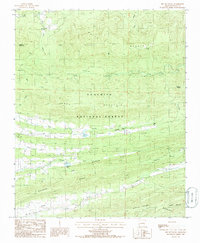
1985 Map of Bee Mountain
USGS Topo · Published 1986About this map
Ouachita National Forest blankets this section of Scott County, where the topography is defined by the sharp, parallel elevations of Waldron Ridge, Narrow Ridge, and Dutch Creek Mountain. The settlement pattern in the mid-1980s was concentrated along the valley floors, with the community of Self situated near a small Cem and Cardiff located further east along the Poteau River. The landscape is a complex network of drainage basins, with the Petit Jean River flowing north while the East Fork Poteau River and Dutch Creek carve through the southern ridges. Small impoundments like Moore Lake and Selkirk Lake serve as local water features amidst the heavily timbered terrain. High-altitude landmarks such as Bee Mountain and White Oak Mountain dominate the skyline, with the latter hosting Radio Towers at its summit, indicating the area's role in regional communication infrastructure.
Find a feature on this map
27 named features on this map. Tap any name to fly to it.
Don’t see what you’re looking for? This feature index may not catch every label — zoom into the map to look around manually.
Map Details
Editions of this 1985 Bee Mountain Map
This is the sole edition of this map. No revisions or reprints were ever made.
Other maps of this area

1879 · Poteau Mountain
USGS Topo · 1:62,500

1887 · Poteau Mountain #1
USGS Topo · 1:62,500

1887 · Mount Ida #2
USGS Topo · 1:62,500

1887 · Magazine Mountain #3
USGS Topo · 1:62,500

1887 · Magazine Mountain
USGS Topo · 1:62,500

1890 · Magazine Mountain
USGS Topo · 1:125,000

1890 · Mount Ida
USGS Topo · 1:125,000

1890 · Fort Smith
USGS Topo · 1:125,000

1890 · Poteau Mountain
USGS Topo · 1:125,000

1899 · Poteau Mountain
USGS Topo · 1:125,000