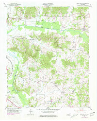
1953 Map of Beech Bluff
USGS Topo · Published 1981About this map
The North Fork Forked Deer River and its southern counterpart carve a distinct topographical path through this West Tennessee landscape, anchoring the community of Beech Bluff. Based on mid-century surveys with updates through the late 1970s, the map reveals a countryside defined by small-scale agrarian settlement and a dense network of spiritual and educational centers. Notable landmarks include Potts Chapel, Isaac Chapel, and Zion Hill Ch, alongside local schools like Beech Bluff Sch and County Line Sch.
Find a feature on this map
34 named features on this map. Tap any name to fly to it.
Don’t see what you’re looking for? This feature index may not catch every label — zoom into the map to look around manually.
Map Details
Editions of this 1953 Beech Bluff Map
3 editions found
Other maps of this area

1950 · Jackson South
USGS Topo · 1:24,000

1950 · Jackson North
USGS Topo · 1:24,000

1951 · Jackson North
USGS Topo · 1:24,000

1953 · Claybrook
USGS Topo · 1:24,000

1953 · Beech Bluff
USGS Topo · 1:24,000

1955 · Luray
USGS Topo · 1:24,000

1955 · Juno
USGS Topo · 1:24,000

1956 · Blytheville
USGS Topo · 1:250,000

1959 · Blytheville
USGS Topo · 1:250,000

1961 · Medon
USGS Topo · 1:24,000