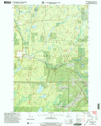
1999 Map of Beechwood
USGS Topo · Published 2004About this map
The Ottawa National Forest encompasses much of this Iron County landscape, where the South Branch Paint River and the Iron River carve through a network of creeks and small glacial lakes. Settlement is concentrated along the southern corridor near the small community of Beechwood, which serves as a local focal point with its Bethany Ch, Townhall, and the nearby Rosehill Cem. This 1999 revision illustrates a region defined by its timber and water resources, showing established routes like Old Beechwood Road and Basswood Road connecting remote outposts like Basswood to the larger river valleys. The presence of several Gravel Pits and industrial pipelines traversing the terrain indicates the ongoing importance of resource extraction and infrastructure in the Upper Peninsula’s interior during the late twentieth century.
Find a feature on this map
28 named features on this map. Tap any name to fly to it.
Don’t see what you’re looking for? This feature index may not catch every label — zoom into the map to look around manually.
Map Details
Editions of this 1999 Beechwood Map
This is the sole edition of this map. No revisions or reprints were ever made.
Other maps of this area

1895 · Perch Lake
USGS Topo · 1:62,500

1898 · Iron River
USGS Topo · 1:62,500

1944 · Iron River
USGS Topo · 1:24,000

1945 · Gibbs City
USGS Topo · 1:24,000

1946 · Iron River
USGS Topo · 1:31,680

1946 · Gibbs City
USGS Topo · 1:31,680

1954 · Kenton
USGS Topo · 1:62,500

1954 · Perch Lake
USGS Topo · 1:62,500

1956 · Beechwood
USGS Topo · 1:62,500

1958 · Iron River
USGS Topo · 1:250,000