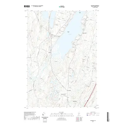
2021 Map of Belgrade
USGS Topo · Published 2021About this map
Messalonskee Lake and Great Pond dominate the northern portion of this Kennebec County landscape, framing the peninsula where the settlement of Belgrade is situated. The terrain is a complex assembly of water and wetlands, including Austin Bog and Great Sidney Bog, which influenced the placement of early roads and cemeteries. A significant concentration of family and community burial grounds, such as Woodside Cem and Friends Cem, are clustered near Sunny Hill Airport, reflecting generations of local residency. To the south, the village of Summerhaven lies near the headwaters of Sidney Bog Brook, while the municipal boundary of Augusta enters the sheet at the southern edge. The map captures a transition from lakefront recreation at Bangs Beach to the rural highlands of Quaker Hill and Lord Hill, illustrating how the region's glacial geography dictated its late-twentieth-century development pattern.
Find a feature on this map
115 named features on this map. Tap any name to fly to it.
Don’t see what you’re looking for? This feature index may not catch every label — zoom into the map to look around manually.
Map Details
Editions of this 2021 Belgrade Map
This is the sole edition of this map. No revisions or reprints were ever made.
Other maps of this area

1892 · Waterville
USGS Topo · 1:62,500

1892 · Augusta
USGS Topo · 1:62,500

1893 · Vassalboro
USGS Topo · 1:62,500

1894 · Norridgewock
USGS Topo · 1:62,500

1898 · Norridgewock
USGS Topo · 1:62,500

1898 · Vassalboro
USGS Topo · 1:62,500

1941 · Vassalboro
USGS Topo · 1:62,500

1941 · Augusta
USGS Topo · 1:62,500

1943 · Augusta
USGS Topo · 1:62,500

1943 · Vassalboro
USGS Topo · 1:62,500