
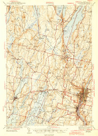
1943 Map of Augusta
USGS Topo · Published 1943About this map
The Kennebec River corridor defines this wartime landscape, where the state capital of Augusta sits at the nexus of the Maine Central railroad and a dense network of inland lakes. This 1941 survey documents the transition between the industrial riverside and the recreational character of the surrounding hills. Large institutional footprints, such as the State Hospital, contrast with the numerous rural schools like Cony Sch and Ballard Sch that served the outlying farming communities.
Find a feature on this map
113 named features on this map. Tap any name to fly to it.
Don’t see what you’re looking for? This feature index may not catch every label — zoom into the map to look around manually.
Map Details
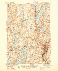
Editions of this 1943 Augusta Map
3 editions found
Other maps of this area

1892 · Gardiner
USGS Topo · 1:62,500

1892 · Waterville
USGS Topo · 1:62,500

1892 · Augusta
USGS Topo · 1:62,500

1893 · Vassalboro
USGS Topo · 1:62,500

1893 · Wiscasset
USGS Topo · 1:62,500

1894 · Norridgewock
USGS Topo · 1:62,500

1898 · Norridgewock
USGS Topo · 1:62,500

1898 · Vassalboro
USGS Topo · 1:62,500

1908 · Lewiston
USGS Topo · 1:62,500

1910 · Livermore
USGS Topo · 1:62,500