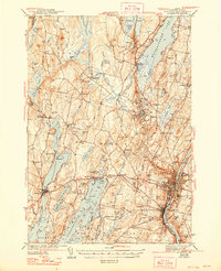
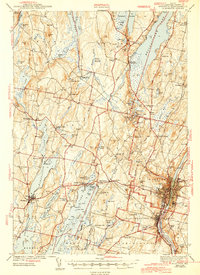
1943 Map of Augusta
USGS Topo · Published 1948About this map
Augusta and Hallowell anchor this mid-century survey, situated along the industrial and transport corridor of the Kennebec River. The landscape is defined by its massive glacial lakes and ponds, where seasonal destinations like Maranacook Camp and Island Park reflect a well-established recreational culture. The Maine Central railroad tracks cut through the terrain, serving inland hubs like Readfield Depot and Winthrop.
Find a feature on this map
131 named features on this map. Tap any name to fly to it.
Don’t see what you’re looking for? This feature index may not catch every label — zoom into the map to look around manually.
Map Details
Editions of this 1943 Augusta Map
3 editions found

Other maps of this area

1892 · Gardiner
USGS Topo · 1:62,500

1892 · Waterville
USGS Topo · 1:62,500

1892 · Augusta
USGS Topo · 1:62,500

1893 · Vassalboro
USGS Topo · 1:62,500

1893 · Wiscasset
USGS Topo · 1:62,500

1894 · Norridgewock
USGS Topo · 1:62,500

1898 · Norridgewock
USGS Topo · 1:62,500

1898 · Vassalboro
USGS Topo · 1:62,500

1908 · Lewiston
USGS Topo · 1:62,500

1910 · Livermore
USGS Topo · 1:62,500