Loading...
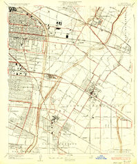
Loading map...1936 Map of Bell
USGS Topo · Published 1936About this map
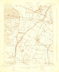
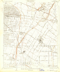
Industrial corridors and growing residential tracts define this 1930s landscape south of Los Angeles, where the Los Angeles River and Rio Hondo carve through the plains. The map captures a critical era of transport and industry, featuring the Rio Grande Oil Refinery and the massive Brickyard near Simons. The region is a dense network of transit, from the Pacific Electric lines to the heavy rails of the Union Pacific RR and Southern Pacific RR.
Find a feature on this map
67 named features on this map. Tap any name to fly to it.
Don’t see what you’re looking for? This feature index may not catch every label — zoom into the map to look around manually.
Map Details
Date Portrayed1936
Date Published1936
PublisherU.S. Geological Survey
Map TypeTopographic
Scale1:24,000
Physical Dimensions17.1 x 20.3 inches
Editions of this 1936 Bell Map
This is the sole edition of this map. No revisions or reprints were ever made.
Historical Maps of Downey Through Time
3 maps found
Featured Locations
Source Details
SourceU.S. Geological Survey
CopyrightPublic Domain