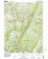
1996 Map of Bellegrove
USGS Topo · Published 1999About this map
Sideling Hill dominates this landscape where Maryland, West Virginia, and Pennsylvania converge. The terrain is defined by the tight meanders of Sideling Hill Creek as it approaches the Potomac River at Turkey Foot Bend. This survey captures a region of significant state-managed lands, including the Green Ridge State Forest and the Sideling Hill State Wildlife Management Area. Historical transit is represented by the National Pike and the CSX Transportation line tracking the northern bank of the Potomac. Local life is centered around rural outposts like Bellegrove and Woodmont, alongside numerous country churches such as St Pauls Ch and Mt Olivet Ch. The map also preserves the site of the Woodmont Club and the high-elevation Relay Station Radio Tower on the ridge crest.
Find a feature on this map
54 named features on this map. Tap any name to fly to it.
Don’t see what you’re looking for? This feature index may not catch every label — zoom into the map to look around manually.
Map Details
Editions of this 1996 Bellegrove Map
This is the sole edition of this map. No revisions or reprints were ever made.
Other maps of this area

1898 · Paw Paw
USGS Topo · 1:62,500

1899 · Hancock
USGS Topo · 1:62,500

1900 · Pawpaw
USGS Topo · 1:62,500

1901 · Hancock
USGS Topo · 1:62,500

1910 · Paw Paw
USGS Topo · 1:62,500

1925 · Needmore
USGS Topo · 1:48,000

1927 · Clearville
USGS Topo · 1:48,000

1931 · Clearville
USGS Topo · 1:62,500

1935 · Needmore
USGS Topo · 1:62,500

1939 · Needmore
USGS Topo · 1:62,500