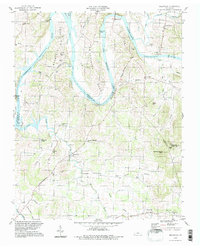
1994 Map of Bellwood
USGS Topo · Published 1997About this map
The Cumberland River carves deep, looping meanders across this landscape, creating the prominent landforms of Beasleys Bend and Puryears Bend. The river's path is marked by high elevations such as Whitleys Bluff and Whites Bluff, overlooking what is now part of Old Hickory Lake. This region at the borders of Wilson, Trousdale, and Smith Counties is characterized by a network of small rural communities and family-named landmarks.
Find a feature on this map
61 named features on this map. Tap any name to fly to it.
Don’t see what you’re looking for? This feature index may not catch every label — zoom into the map to look around manually.
Map Details
Editions of this 1994 Bellwood Map
This is the sole edition of this map. No revisions or reprints were ever made.
Other maps of this area

1942 · Statesville
USGS Topo · 1:100,000

1942 · Gallatin
USGS Topo · 1:100,000

1942 · Lebanon
USGS Topo · 1:100,000

1951 · Lebanon
USGS Topo · 1:24,000

1955 · Bethpage
USGS Topo · 1:24,000

1955 · Hunters Point
USGS Topo · 1:24,000

1956 · Nashville
USGS Topo · 1:250,000

1958 · New Middleton
USGS Topo · 1:24,000

1958 · Bellwood
USGS Topo · 1:24,000

1958 · Dixon Springs
USGS Topo · 1:24,000