1972 Map of Belpre
USGS Topo · Published 1974About this map
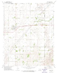
Belpre serves as the focal point of this southwestern Kansas landscape, situated where the Atchison Topeka and Santa Fe railroad crosses the plains. The 1970s survey reveals a region defined by agricultural parcels and an extensive energy infrastructure, with numerous Oil Wells and Gas Wells dotting the township boundaries of Farmington, Belpre, and Lincoln. Water is scarce in this high-plains environment, represented primarily by the seasonal channels of Wild Horse Creek and Clear Creek. The town itself is marked by local utilities including a Substation and a Radio Tower, reflecting the modern technical needs of this rural community. Researchers will find the map captures a specific era of resource extraction and transit, evidenced by the high concentration of wells and the prominent rail line that historically shaped the town's development.
Find a feature on this map
14 named features on this map. Tap any name to fly to it.
Don’t see what you’re looking for? This feature index may not catch every label — zoom into the map to look around manually.
Map Details
Editions of this 1972 Belpre Map
This is the sole edition of this map. No revisions or reprints were ever made.
Other maps of this area

1889 · Larned
USGS Topo · 1:125,000

1889 · Kinsley
USGS Topo · 1:125,000

1891 · Great Bend
USGS Topo · 1:125,000

1891 · Larned
USGS Topo · 1:125,000

1892 · Kinsley
USGS Topo · 1:125,000

1892 · Pratt
USGS Topo · 1:125,000

1893 · Great Bend
USGS Topo · 1:125,000

1894 · Kinsley
USGS Topo · 1:125,000

1894 · Pratt
USGS Topo · 1:125,000

1955 · Great Bend
USGS Topo · 1:250,000