
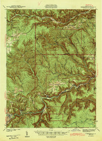
1943 Map of Benezette
USGS Topo · Published 1943About this map
Benezette serves as the focal point of this 1940s survey, situated along the Pennsylvania railroad line as it follows the winding path of Sinnemahoning Creek. The landscape is defined by the deep valleys of the Elk State Forest, where numerous timbering-era landmarks like Sawdust Run and Hellfire Run hint at the region's industrial past. The settlement patterns of Elk and Cameron counties are clearly marked by rural institutions, including Mt Pleasant Ch and Grant Ch, as well as schools such as Bryan Hill Sch and Whitimore Sch.
Find a feature on this map
64 named features on this map. Tap any name to fly to it.
Don’t see what you’re looking for? This feature index may not catch every label — zoom into the map to look around manually.
Map Details
Editions of this 1943 Benezette Map
2 editions found
Other maps of this area

1929 · Karthaus
USGS Topo · 1:62,500

1929 · Clearfield
USGS Topo · 1:48,000

1929 · Penfield
USGS Topo · 1:62,500

1932 · Clearfield
USGS Topo · 1:62,500

1932 · Penfield
USGS Topo · 1:62,500

1932 · Karthaus
USGS Topo · 1:62,500

1935 · Mt. Jewett
USGS Topo · 1:48,000

1940 · Mt. Jewett
USGS Topo · 1:62,500

1941 · Benezette
USGS Topo · 1:62,500

1941 · Ridgway
USGS Topo · 1:62,500