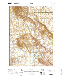
2020 Map of Benjamin Lake
USGS Topo · Published 2020About this map
Benjamin Lake sits at the southern reach of this arid basin along the border of Deschutes and Lake Counties. The landscape is defined by its intermittent hydrology and volcanic topography, where water sources like Mahogany Waterhole and Great Basin Waterhole provided essential stops in an otherwise dry high-desert environment. Notable high points such as Yreka Butte, Harder Butte, and East Butte rise above the surrounding flats, including Mahogany Flat and Trail Flat. The distribution of these named landmarks suggests a history of cattle ranging or early travel through the High Desert, as seasonal lakes like Rock Lake and Midway Lake appear scattered across the sections. The complex drainage patterns of Wells Draw and Elvies Canyon further reveal the erosional forces at work on the eastern slope of Benjamin Point, illustrating the geological character of the Oregon outback before more modern developments reached this remote interior.
Find a feature on this map
22 named features on this map. Tap any name to fly to it.
Don’t see what you’re looking for? This feature index may not catch every label — zoom into the map to look around manually.
Map Details
Editions of this 2020 Benjamin Lake Map
This is the sole edition of this map. No revisions or reprints were ever made.
Other maps of this area

1955 · Crescent
USGS Topo · 1:250,000

1957 · Crescent
USGS Topo · 1:250,000

1958 · Crescent
USGS Topo · 1:250,000

1970 · Crescent
USGS Topo · 1:250,000

1981 · Moonlight Butte
USGS Topo · 1:24,000

1981 · Mean Rock Well
USGS Topo · 1:24,000

1981 · Chicago Valley
USGS Topo · 1:24,000

1983 · Potato Lake
USGS Topo · 1:24,000

1983 · Imperial Valley South
USGS Topo · 1:24,000

1983 · Benjamin Lake
USGS Topo · 1:24,000