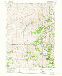
1966 Map of Bernard
USGS Topo · Published 1967About this map
Bernard serves as the central hub for this rural stretch of Eastern Iowa, situated precisely along the border of Dubuque and Jackson Counties. The landscape is defined by the winding paths of Prairie Creek and the intricate, meandering course of Lytle Creek, which carves through the eastern half of the township. Local infrastructure in the mid-1960s was anchored by community institutions like the Townhall and a network of parish and public schools including Sacred Heart Sch and West Dubuque Sch.
Find a feature on this map
21 named features on this map. Tap any name to fly to it.
Don’t see what you’re looking for? This feature index may not catch every label — zoom into the map to look around manually.
Map Details
Editions of this 1966 Bernard Map
2 editions found
Other maps of this area

1891 · Maquoketa
USGS Topo · 1:62,500

1891 · Baldwin
USGS Topo · 1:62,500

1901 · Peosta
USGS Topo · 1:125,000

1935 · East Dubuque
USGS Topo · 1:62,500

1940 · East Dubuque
USGS Topo · 1:62,500

1955 · Dubuque South
USGS Topo · 1:24,000

1959 · Dubuque
USGS Topo · 1:250,000

1961 · Dubuque
USGS Topo · 1:250,000

1962 · Dubuque
USGS Topo · 1:250,000

1962 · Zwingle
USGS Topo · 1:24,000