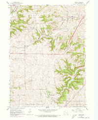
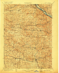
1901 Map of Peosta
USGS Topo · Published 1901About this map
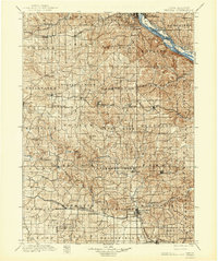
The Mississippi River defines the northeastern edge of this survey, where the Illinois Central RR Dubuque Division and Chicago Burlington and Northern RR converge near East Dubuque. Moving inland, the landscape is defined by the high prominence of Table Mound and a dense network of drainages including the North Fork Maquoketa River and Lytle Creek. This era reveals a high density of rural settlements and milling sites, such as Washington Mills, Clay Mills, and the religious community of Melleray. In the southern portion, the Maquoketa River winds through Maquoketa, served by the Clinton and Anamosa Line. This detailed topography captures the transition from river-based commerce to the expanding dominance of rail lines like the Chicago Milwaukee and St Paul RR across the Dubuque and Jackson county lines.
Find a feature on this map
100 named features on this map. Tap any name to fly to it.
Don’t see what you’re looking for? This feature index may not catch every label — zoom into the map to look around manually.
Map Details
Editions of this 1901 Peosta Map
4 editions found
Historical Maps of Dubuque Through Time
7 maps found