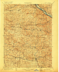
1901 Map of Peosta
USGS Topo · Published 1917About this map
The Mississippi River creates a natural corridor through this landscape at the turn of the century, where the river valley meets the upland prairies of eastern Iowa. The city of Dubuque sits as a vital rail and river hub, connected to East Dubuque and served by multiple major lines including the Illinois Central and the Chicago Great Western. The map reveals a dense network of early settlements and rural post points, such as Key West, St Donatus, and Garry Owen, illustrating the era's agrarian settlement patterns before modern highway consolidation. Waterways like the North Fork Maquoketa River and Tete de Mort River carve through the terrain, dictating the placement of early centers like Washington Mills. This survey, compiled from work by Jno. H. Renshawe and his team, provides a detailed look at the township divisions and early railroad spurs that defined Dubuque and Jackson counties during this formative period.
Find a feature on this map
102 named features on this map. Tap any name to fly to it.
Don’t see what you’re looking for? This feature index may not catch every label — zoom into the map to look around manually.
Map Details
Editions of this 1901 Peosta Map
4 editions found

Other maps of this area

1889 · Tipton
USGS Topo · 1:62,500

1890 · Tipton
USGS Topo · 1:62,500

1891 · DeWitt
USGS Topo · 1:62,500

1891 · Monticello
USGS Topo · 1:62,500

1891 · Maquoketa
USGS Topo · 1:62,500

1891 · Baldwin
USGS Topo · 1:62,500

1892 · Wheatland
USGS Topo · 1:62,500

1892 · Goose Lake
USGS Topo · 1:62,500

1894 · Wheatland
USGS Topo · 1:62,500

1894 · Goose Lake
USGS Topo · 1:62,500