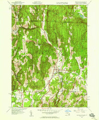
1945 Map of Bernardston
USGS Topo · Published 1958About this map
The Falls River valley carves through the heart of this borderland landscape, where the Boston and Maine Railroad follows the water's edge south toward Bernardston. This 1945 revision reveals a countryside defined by small-scale educational and spiritual hubs, including The Old Chapel and a network of rural schoolhouses such as Baker Sch, Beaver Meadow Sch, and Sunnyside Sch. The map documents a period when local infrastructure was transitioning, evidenced by the Greenfield Reservoir and the nearby Greenfield Filter Plant nestled in the western hills near Frizzell Hill.
Find a feature on this map
57 named features on this map. Tap any name to fly to it.
Don’t see what you’re looking for? This feature index may not catch every label — zoom into the map to look around manually.
Map Details
Editions of this 1945 Bernardston Map
This is the sole edition of this map. No revisions or reprints were ever made.
Other maps of this area

1887 · Warwick
USGS Topo · 1:62,500

1889 · Warwick
USGS Topo · 1:62,500

1890 · Greenfield
USGS Topo · 1:62,500

1891 · Brattleboro
USGS Topo · 1:62,500

1893 · Brattleboro
USGS Topo · 1:62,500

1894 · Greenfield
USGS Topo · 1:62,500

1894 · Warwick
USGS Topo · 1:62,500

1898 · Keene
USGS Topo · 1:62,500

1932 · Brattleboro
USGS Topo · 1:48,000

1932 · Warwick
USGS Topo · 1:48,000