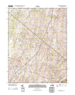
2013 Map of Berryville
USGS Topo · Published 2013About this map
The Shenandoah River flows through the southeastern corner of this landscape, anchoring a region defined by established estates and historic spring-fed agriculture. Named estates like Lang Syne Estate and Cedar Grove Estate dot the periphery of Berryville, reflecting the area's long-standing land-use patterns. The map captures a high density of named water sources, such as the Fairfax Grant Farm Springs and Joseph Bell Farm Spring, indicating the vital importance of groundwater to these historic farmsteads.
Find a feature on this map
180 named features on this map. Tap any name to fly to it.
Don’t see what you’re looking for? This feature index may not catch every label — zoom into the map to look around manually.
Map Details
Editions of this 2013 Berryville Map
This is the sole edition of this map. No revisions or reprints were ever made.
Other maps of this area

1884 · Harpers Ferry
USGS Topo · 1:125,000

1891 · Harpers Ferry
USGS Topo · 1:125,000

1893 · Harpers Ferry
USGS Topo · 1:125,000

1894 · Winchester
USGS Topo · 1:125,000

1914 · Martinsburg
USGS Topo · 1:48,000

1914 · Gerrardstown
USGS Topo · 1:48,000

1916 · Gerrardstown
USGS Topo · 1:62,500

1916 · Martinsburg
USGS Topo · 1:62,500

1916 · Berryville
USGS Topo · 1:62,500

1937 · Gerrardstown
USGS Topo · 1:48,000