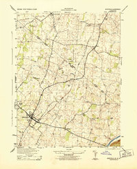
1944 Map of Berryville
USGS Topo · Published 1944About this map
The Berryville area during the mid-1940s is defined by its deep agricultural roots and the critical transit corridors of the Shenandoah Valley. This landscape is a patchwork of small settlements and family holdings situated along the Norfolk and Western and Baltimore and Ohio railroads. The topography is marked by several watercourses including Bullskin Run and Dog Run, which flow toward the Shenandoah River in the southeast corner. The presence of Peagans Mill on Bullskin Run suggests the long-standing importance of water-powered industry in this rural economy. Significant local landmarks such as Beulah Church, Marvin Chapel, and Bethel Church are central to the social fabric of these communities. Many smaller hamlets like Summit Point, Rippon, and Gaylord serve as focal points for the surrounding farms and homesteads, providing a clear view of the region's historic settlement patterns.
Find a feature on this map
34 named features on this map. Tap any name to fly to it.
Don’t see what you’re looking for? This feature index may not catch every label — zoom into the map to look around manually.
Map Details
Editions of this 1944 Berryville Map
This is the sole edition of this map. No revisions or reprints were ever made.
Other maps of this area

1884 · Harpers Ferry
USGS Topo · 1:125,000

1891 · Harpers Ferry
USGS Topo · 1:125,000

1893 · Harpers Ferry
USGS Topo · 1:125,000

1894 · Winchester
USGS Topo · 1:125,000

1914 · Martinsburg
USGS Topo · 1:48,000

1914 · Gerrardstown
USGS Topo · 1:48,000

1916 · Gerrardstown
USGS Topo · 1:62,500

1916 · Martinsburg
USGS Topo · 1:62,500

1916 · Berryville
USGS Topo · 1:62,500

1937 · Gerrardstown
USGS Topo · 1:48,000