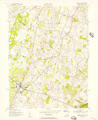
1955 Map of Berryville
USGS Topo · Published 1956About this map
Berryville serves as the focal point of this mid-1950s survey of the Shenandoah Valley, situated at the intersection of critical rail and road corridors. The landscape is defined by the crossing of the Baltimore and Ohio and the Norfolk and Western railroads, which facilitated the movement of goods through small agricultural hubs like Rippon and Gaylord. Along the eastern edge, the Shenandoah River is spanned by the Castleman Ferry Bridge, providing a vital link between the fertile valley floor and the rising terrain to the east.
Find a feature on this map
40 named features on this map. Tap any name to fly to it.
Don’t see what you’re looking for? This feature index may not catch every label — zoom into the map to look around manually.
Map Details
Editions of this 1955 Berryville Map
This is the sole edition of this map. No revisions or reprints were ever made.
Other maps of this area

1884 · Harpers Ferry
USGS Topo · 1:125,000

1891 · Harpers Ferry
USGS Topo · 1:125,000

1893 · Harpers Ferry
USGS Topo · 1:125,000

1894 · Winchester
USGS Topo · 1:125,000

1914 · Martinsburg
USGS Topo · 1:48,000

1914 · Gerrardstown
USGS Topo · 1:48,000

1916 · Gerrardstown
USGS Topo · 1:62,500

1916 · Martinsburg
USGS Topo · 1:62,500

1916 · Berryville
USGS Topo · 1:62,500

1937 · Gerrardstown
USGS Topo · 1:48,000