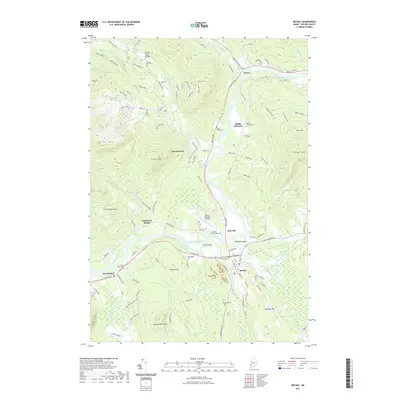
2021 Map of Bethel
USGS Topo · Published 2021About this map
The Androscoggin River carves a broad valley through this mountain landscape, anchoring a network of small settlements including Newry, Middle Intervale, and Bethel. This corridor has long served as a vital transit route, evidenced by the cluster of burial grounds like Grafton Cem and Sunday River Cem that mark early family homesteads. To the west, the slopes of Barker Mtn and Locke Mtn rise sharply, while the river's meandering path creates landforms like Bond Island and Hastings Island. The area around Mayville shows a transition toward modern infrastructure with the Bethel Regional Airport, yet the landscape remains defined by the numerous brooks—such as Sunday River and Bear River—that drain the surrounding peaks into the main valley. Genealogists can find several smaller community landmarks, including Skillingston Cem near West Bethel and Woodland Cem to the south.
Find a feature on this map
128 named features on this map. Tap any name to fly to it.
Don’t see what you’re looking for? This feature index may not catch every label — zoom into the map to look around manually.
Map Details
Editions of this 2021 Bethel Map
This is the sole edition of this map. No revisions or reprints were ever made.
Other maps of this area

1911 · Bryant Pond
USGS Topo · 1:62,500

1914 · Bethel
USGS Topo · 1:62,500

1914 · Bryant Pond
USGS Topo · 1:62,500

1927 · Rumford
USGS Topo · 1:48,000

1930 · Rumford
USGS Topo · 1:62,500

1940 · Bethel
USGS Topo · 1:62,500

1941 · Bethel
USGS Topo · 1:62,500

1942 · Bryant Pond
USGS Topo · 1:62,500

1943 · Old Speck Mtn
USGS Topo · 1:62,500

1945 · Old Speck Mtn
USGS Topo · 1:62,500