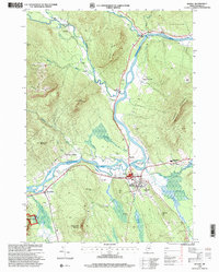
1995 Map of Bethel
USGS Topo · Published 2000About this map
The Androscoggin River flows through the heart of the Oxford Hills in the mid-1990s, shaping the settlement patterns of Bethel and its surrounding hamlets. This landscape is defined by the transition from the fertile river valley floor to the high peaks of the White Mountain National Forest, including Barker Mountain and Locke Mountain. The map captures the significant winter recreation infrastructure at the Sunday River Ski Area, with its network of ski lifts contrasted against the agricultural history of Middle Intervale and Mayville. Cultural landmarks such as the Gould Academy campus and the historic Covered Bridge near Newry illustrate the region's dual identity as both an educational hub and a gateway to the Maine wilderness. Numerous small burial grounds, including Skillington Cemetery and Woodland Cemetery, provide essential reference points for those researching local family lineages.
Find a feature on this map
58 named features on this map. Tap any name to fly to it.
Don’t see what you’re looking for? This feature index may not catch every label — zoom into the map to look around manually.
Map Details
Editions of this 1995 Bethel Map
This is the sole edition of this map. No revisions or reprints were ever made.
Other maps of this area

1911 · Bryant Pond
USGS Topo · 1:62,500

1914 · Bethel
USGS Topo · 1:62,500

1914 · Bryant Pond
USGS Topo · 1:62,500

1927 · Rumford
USGS Topo · 1:48,000

1930 · Rumford
USGS Topo · 1:62,500

1940 · Bethel
USGS Topo · 1:62,500

1941 · Bethel
USGS Topo · 1:62,500

1942 · Bryant Pond
USGS Topo · 1:62,500

1943 · Old Speck Mtn
USGS Topo · 1:62,500

1945 · Old Speck Mtn
USGS Topo · 1:62,500