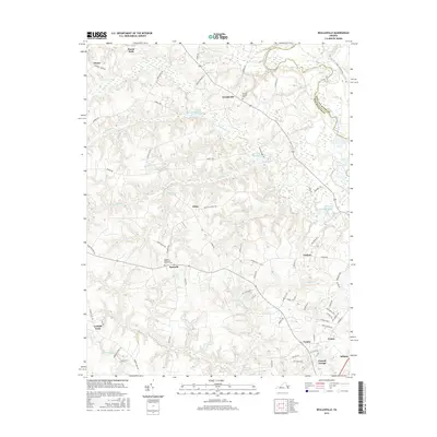
2016 Map of Beulahville
USGS Topo · Published 2016About this map
Beulahville and the surrounding coastal plain of King William County are defined by a network of creeks and millponds that flow toward the Mattaponi River. This landscape reflects a long history of water-powered industry and rural community life, evidenced by the numerous ponds like Dublin Millpond, Mitchell Millpond, and Herring Cr Millpond distributed across the drainage basins of Herring Cr and Fork Bridge Cr. Small crossroads and settlements such as Epworth, Upshaw, and Venter serve as local anchors, many centered around established congregations and resting places like the Epworth Methodist Church Cem and Beulah Church Cem. The southern portion of the map transitions into the low-lying reaches of Governor Swamp and Aylett Cr, while modern commerce congregates near Central Garage and Midway.
Find a feature on this map
74 named features on this map. Tap any name to fly to it.
Don’t see what you’re looking for? This feature index may not catch every label — zoom into the map to look around manually.
Map Details
Editions of this 2016 Beulahville Map
This is the sole edition of this map. No revisions or reprints were ever made.
Other maps of this area

1894 · Richmond
USGS Topo · 1:62,500

1895 · Richmond
USGS Topo · 1:62,500

1918 · Doswell
USGS Topo · 1:62,500

1918 · Aylett
USGS Topo · 1:62,500

1920 · King William
USGS Topo · 1:62,500

1933 · Aylett
USGS Topo · 1:62,500

1938 · Studley
USGS Topo · 1:31,680

1943 · Richmond
USGS Topo · 1:250,000
1949 · King William
USGS Topo · 1:24,000
1949 · Aylett
USGS Topo · 1:24,000