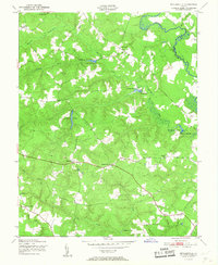
1951 Map of Beulahville
USGS Topo · Published 1951About this map
Mattaponi River curves through the northeast corner of this Tidewater landscape, marking the boundary between King William and King and Queen counties. The interior terrain is defined by a dense network of tributaries including Herring Creek, Webb Creek, and Dorrell Creek, which supported a localized milling economy mid-century. Evidence of this water-powered industry remains visible at Mitchell Mill Pond and Herring Creek Mill, along with the secluded Dublin Mill Pond. Small crossroads settlements and post offices such as Beulahville, Pollards Corner, and Epworth serve as the primary hubs for the surrounding rural homesteads. The map also records localized landmarks like Corinth Ch and Duane Fork, offering a detailed view of the road network and agricultural clearings that shaped this part of Virginia just after the 1940s.
Find a feature on this map
27 named features on this map. Tap any name to fly to it.
Don’t see what you’re looking for? This feature index may not catch every label — zoom into the map to look around manually.
Map Details
Editions of this 1951 Beulahville Map
This is the sole edition of this map. No revisions or reprints were ever made.
Other maps of this area

1894 · Richmond
USGS Topo · 1:62,500

1895 · Richmond
USGS Topo · 1:62,500

1918 · Doswell
USGS Topo · 1:62,500

1918 · Aylett
USGS Topo · 1:62,500

1920 · King William
USGS Topo · 1:62,500

1933 · Aylett
USGS Topo · 1:62,500

1938 · Studley
USGS Topo · 1:31,680

1943 · Richmond
USGS Topo · 1:250,000
1949 · King William
USGS Topo · 1:24,000
1949 · Aylett
USGS Topo · 1:24,000