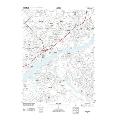
2011 Map of Beverly
USGS Topo · Published 2011About this map
The Delaware River separates the dense residential corridors of Pennsylvania and New Jersey on this detailed 2011 map. In Pennsylvania, the sprawling suburban character of Bensalem and Parkwood Manor is defined by transit and industry, including the Septa rail lines and the presence of significant infrastructure like Franklin Mills and the Keystone Race Track. Across the water, the New Jersey side features a mix of established residential communities like Beverly and Riverside, punctuated by open spaces and historic sites. Beverly National Cemetery sits near the riverbank, a major landmark in a region that balances industrial hubs and quiet neighborhoods. The geography is deeply influenced by the waterways of the Neshaminy Creek, Poquessing Creek, and Rancocas Creek, which serve as natural boundaries between the various boroughs and townships. These creeks provided the foundation for the area's development, now marked by a network of modern interstate highways including I-95.
Find a feature on this map
145 named features on this map. Tap any name to fly to it.
Don’t see what you’re looking for? This feature index may not catch every label — zoom into the map to look around manually.
Map Details
Editions of this 2011 Beverly Map
This is the sole edition of this map. No revisions or reprints were ever made.
Other maps of this area

1888 · Mount Holly
USGS Topo · 1:62,500

1890 · Burlington
USGS Topo · 1:62,500

1891 · Philadelphia
USGS Topo · 1:62,500

1893 · Germantown
USGS Topo · 1:62,500

1893 · Burlington
USGS Topo · 1:62,500

1894 · Mount Holly
USGS Topo · 1:62,500

1894 · Philadelphia
USGS Topo · 1:62,500

1894 · Germantown
USGS Topo · 1:62,500

1896 · Germantown
USGS Topo · 1:62,500

1896 · Philadelphia
USGS Topo · 1:62,500
Featured Places
- Philadelphia, PA
- Bensalem Township, PA
- Mount Laurel Township, NJ
- Willingboro Township, NJ
- Moorestown Township, NJ