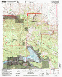
1996 Map of Big Bear City
USGS Topo · Published 1999About this map
Big Bear Lake and the high-altitude landscape of Bear Valley define this mid-1990s survey of the San Bernardino Mountains. The map documents a complex mix of wilderness preservation and industrial history, from the Bighorn Mountain Wilderness to the legacy of mining on Gold Mountain. Settlements like Big Bear City and Sugarloaf are shown in detail, including municipal infrastructure such as the Big Bear City Airport and Fire Station. Evidence of the region's gold-seeking past is widespread, with the Doble Mine and Mohawk Mine situated near the edges of Holcomb Valley. The map also captures the stark contrast between the residential developments near the lake and the industrial operations at Cushenbury Pit, while the National Pacific Crest Trail and Scenic Road wind through the surrounding timber and ridges.
Find a feature on this map
90 named features on this map. Tap any name to fly to it.
Don’t see what you’re looking for? This feature index may not catch every label — zoom into the map to look around manually.
Map Details
Editions of this 1996 Big Bear City Map
This is the sole edition of this map. No revisions or reprints were ever made.
Other maps of this area

1901 · Southern California Sheet No. 1
USGS Topo · 1:250,000

1902 · San Gorgonio
USGS Topo · 1:125,000

1904 · Southern California Sheet No. 1
USGS Topo · 1:250,000

1947 · Lucerne Valley
USGS Topo · 1:62,500

1949 · Lucerne Valley
USGS Topo · 1:62,500

1953 · San Bernardino
USGS Topo · 1:250,000

1954 · San Gorgonio Mountain
USGS Topo · 1:62,500

1955 · Old Woman Springs
USGS Topo · 1:62,500

1955 · Morongo Valley
USGS Topo · 1:62,500

1956 · San Bernardino
USGS Topo · 1:250,000