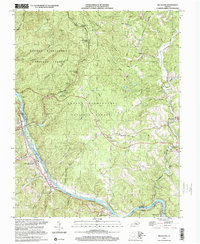
1999 Map of Big Island
USGS Topo · Published 2001About this map
The James River carves a deep valley through the Virginia landscape on this sheet, defining the border between Bedford and Amherst counties. The winding Blue Ridge Parkway tracks the western ridges, offering a series of high-elevation points such as the Otter Creek Flats Overlook and the The Riffles Overlook. This corridor is primarily managed as part of the George Washington National Forest, where steep terrain funnels numerous tributaries like Love Lady Creek and Dancing Creek toward the larger river basins.
Find a feature on this map
65 named features on this map. Tap any name to fly to it.
Don’t see what you’re looking for? This feature index may not catch every label — zoom into the map to look around manually.
Map Details
Editions of this 1999 Big Island Map
This is the sole edition of this map. No revisions or reprints were ever made.
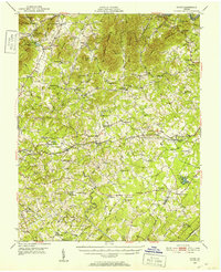
Other maps of this area

1892 · Lynchburg
USGS Topo · 1:125,000

1894 · Lexington
USGS Topo · 1:125,000

1935 · Buena Vista
USGS Topo · 1:48,000

1935 · Amherst
USGS Topo · 1:48,000

1939 · Amherst
USGS Topo · 1:62,500

1939 · Buena Vista
USGS Topo · 1:62,500

1940 · Buena Vista
USGS Topo · 1:62,500

1944 · Lynchburg
USGS Topo · 1:62,500

1947 · Roanoke
USGS Topo · 1:250,000
1950 · Goode
USGS Topo · 1:62,500