Loading...
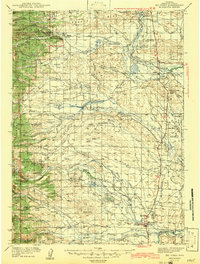
Loading map...1942 Map of Big Piney
USGS Topo · Published 1942About this map
Green River waters define the valley life of western Wyoming in this early 1940s survey, anchoring a network of cattle-raising settlements and early frontier landmarks. The map documents significant historical points such as the Site of Old Ft Bonneville and the Father De Smet Monument, marking the convergence of early fur trade history and missionary travel near the town of Daniel.
Find a feature on this map
61 named features on this map. Tap any name to fly to it.
Don’t see what you’re looking for? This feature index may not catch every label — zoom into the map to look around manually.
Map Details
Date Portrayed1942
Date Published1942
PublisherU.S. Geological Survey
Map TypeTopographic
Scale1:125,000
Physical Dimensions15 x 19.8 inches
Editions of this 1942 Big Piney Map
This is the sole edition of this map. No revisions or reprints were ever made.
Historical Maps of Marbleton Through Time
Featured Locations
Source Details
SourceU.S. Geological Survey
CopyrightPublic Domain