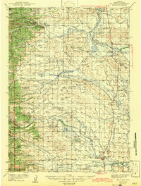
1939 Map of Big Piney
USGS Topo · Published 1957About this map
The Green River basin and the foothills of the Bridger National Forest define this landscape as it appeared in the late 1930s. Centered around the settlement of Big Piney and its neighbor Marbleton, the map illustrates a region deeply connected to its pioneer history and cattle-ranching roots. The historic Lander Trail cuts across the southern portion of the sheet, while landmarks such as the Site of Old Ft Bonneville and the Father De Smet Monument mark significant points of nineteenth-century exploration and missionary work. A complex network of irrigation ditches and creeks, including North Piney Creek and Horse Creek, supports the valley's agriculture. Cultural centers of the era are visible through scattered country schools like Beaver Sch and Middle Piney Sch, alongside the State Fish Hatchery and the local Rodeo Grounds.
Find a feature on this map
57 named features on this map. Tap any name to fly to it.
Don’t see what you’re looking for? This feature index may not catch every label — zoom into the map to look around manually.
Map Details
Editions of this 1939 Big Piney Map
This is the sole edition of this map. No revisions or reprints were ever made.