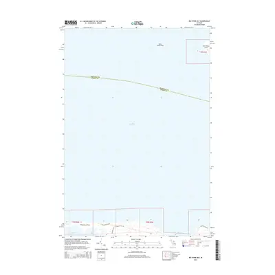
2014 Map of Big Stone Bay
USGS Topo · Published 2014About this map
Saint Helena Island and its surrounding waters define this coastal interface at the northern reach of Lake Michigan. The map illustrates the specialized maritime geography where Emmet County meets Mackinac County in the Straits region. The shoreline is characterized by complex indentations including Big Stone Bay, Goose Bay, and Sturgeon Bay, separated by the prominent landform of Waugoshance Point. Navigation and shoreline access are facilitated by W Wilderness Park Dr and Sturgeon Bay Rd, which provide entry into the coastal landscape. Offshore, the Saint Helena Shoal indicates the submerged hazards common to this part of the Great Lakes shipping corridor. The map's focus is primarily on the natural coastline and public access routes rather than dense inland settlement, reflecting the area's role as a northern Michigan wilderness frontier.
Find a feature on this map
14 named features on this map. Tap any name to fly to it.
Don’t see what you’re looking for? This feature index may not catch every label — zoom into the map to look around manually.
Map Details
Editions of this 2014 Big Stone Bay Map
This is the sole edition of this map. No revisions or reprints were ever made.
Other maps of this area

1931 · Moran NE
USGS Topo · 1:31,680

1948 · Moran NE
USGS Topo · 1:31,680

1948 · Moran NW
USGS Topo · 1:31,680

1955 · Cheboygan
USGS Topo · 1:250,000

1958 · Cheboygan
USGS Topo · 1:250,000

1958 · Cross Village
USGS Topo · 1:62,500

1958 · Pellston
USGS Topo · 1:62,500

1964 · Big Stone Bay
USGS Topo · 1:24,000
1964 · Moran
USGS Topo · 1:24,000
1964 · Pointe Aux Chenes
USGS Topo · 1:24,000