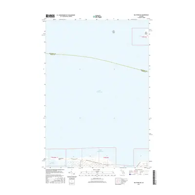
2017 Map of Big Stone Bay
USGS Topo · Published 2017About this map
Wilderness State Park anchors the southern coastline of this map, where the tip of Michigan's Lower Peninsula meets the expanse of Lake Michigan. The shoreline is defined by dramatic coastal features, including the long projection of Waugoshance Point and the shallow waters of Goose Bay and Big Stone Bay. These waters were historically significant for Great Lakes navigation, evidenced by the presence of Saint Helena Shoal and Saint Helena Island to the north, which sits just across the maritime boundary of Mackinac and Emmet Counties. Interior access is limited to a few specific routes like the Wilderness Park Scenic Drive and the Nebo Trail, reflecting the preserved and primitive nature of the landscape in the early 21st century. The map provides a detailed view of the complex wetland and coastal systems that characterize this remote northern Michigan shore.
Find a feature on this map
12 named features on this map. Tap any name to fly to it.
Don’t see what you’re looking for? This feature index may not catch every label — zoom into the map to look around manually.
Map Details
Editions of this 2017 Big Stone Bay Map
This is the sole edition of this map. No revisions or reprints were ever made.
Other maps of this area

1931 · Moran NE
USGS Topo · 1:31,680

1948 · Moran NE
USGS Topo · 1:31,680

1948 · Moran NW
USGS Topo · 1:31,680

1955 · Cheboygan
USGS Topo · 1:250,000

1958 · Cheboygan
USGS Topo · 1:250,000

1958 · Cross Village
USGS Topo · 1:62,500

1958 · Pellston
USGS Topo · 1:62,500

1964 · Big Stone Bay
USGS Topo · 1:24,000
1964 · Moran
USGS Topo · 1:24,000
1964 · Pointe Aux Chenes
USGS Topo · 1:24,000