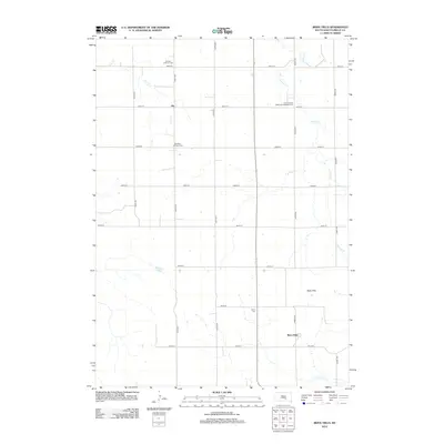
2012 Map of Bijou Hills
USGS Topo · Published 2012About this map
German Lutheran Cem and Saint Vencels Bohemian National Cem reveal the diverse immigrant heritage of this prairie landscape in Brule County. The rural crossroads of Ola and the community at Bijou Hills serve as central points for a region defined by a systematic grid of section roads and small watercourses. To the north and east, drainage from Elm Cr and Nelson Cr carves subtle relief into the terrain, while the southwestern corner is marked by America Lake. The density of denominational burial sites, including the Swedish Lutheran Cem and Union Cem, suggests a history of localized rural parishes that anchored early settlement patterns. This 2012 survey captures the contemporary infrastructure of the area, from 260th Street down to the southern boundary near Snake Cr, reflecting a landscape dedicated to agriculture and organized around small, established rural nodes.
Find a feature on this map
24 named features on this map. Tap any name to fly to it.
Don’t see what you’re looking for? This feature index may not catch every label — zoom into the map to look around manually.
Map Details
Editions of this 2012 Bijou Hills Map
This is the sole edition of this map. No revisions or reprints were ever made.
Other maps of this area

1940 · Iona
USGS Topo · 1:62,500

1944 · Iona
USGS Topo · 1:62,500

1955 · Mitchell
USGS Topo · 1:250,000

1959 · Mitchell
USGS Topo · 1:250,000

1971 · Lucas NW
USGS Topo · 1:24,000

1971 · Academy
USGS Topo · 1:24,000

1971 · Dixon NE
USGS Topo · 1:24,000
1974 · Bond Bottom
USGS Topo · 1:24,000

1974 · Red Lake West
USGS Topo · 1:24,000

1979 · Bijou Hills NE
USGS Topo · 1:24,000