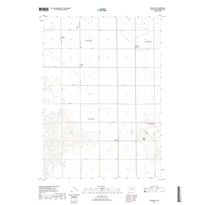
2017 Map of Bijou Hills
USGS Topo · Published 2017About this map
The Bijou Hills dominate the southern landscape of this Brule County quadrangle, rising above a network of section-line roads and prairie drainages. The small settlement of Ola serves as a central point in an area defined by its deep immigrant roots, as evidenced by the high density of denominational and ethnic burial grounds. Local genealogists will find several distinct sites, including the German Lutheran Cem, Amunid Emmanual Lutheran Cem, and the Swedish Lutheran Cem, alongside the Saint Vencels Bohemian National Cem to the east. These labels reflect the specific European settlement patterns that shaped the South Dakota plains. Water features are concentrated in the north and central regions, including Panzour Dam on Nelson Creek, the waters of America Lake, and the winding course of Elm Creek. The southern portion of the map is defined by the elevation changes of the hills and the seasonal flow of Snake Creek.
Find a feature on this map
27 named features on this map. Tap any name to fly to it.
Don’t see what you’re looking for? This feature index may not catch every label — zoom into the map to look around manually.
Map Details
Editions of this 2017 Bijou Hills Map
This is the sole edition of this map. No revisions or reprints were ever made.
Other maps of this area

1940 · Iona
USGS Topo · 1:62,500

1944 · Iona
USGS Topo · 1:62,500

1955 · Mitchell
USGS Topo · 1:250,000

1959 · Mitchell
USGS Topo · 1:250,000

1971 · Lucas NW
USGS Topo · 1:24,000

1971 · Academy
USGS Topo · 1:24,000

1971 · Dixon NE
USGS Topo · 1:24,000
1974 · Bond Bottom
USGS Topo · 1:24,000

1974 · Red Lake West
USGS Topo · 1:24,000

1979 · Bijou Hills NE
USGS Topo · 1:24,000