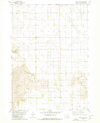
1979 Map of Bijou Hills
USGS Topo · Published 1980About this map
Bijou Hills and the surrounding high ground of South Dakota's Brule County are documented here in detail during the late 1970s. The landscape is defined by the sharp transition between the agricultural plateaus and the drainage systems of Elm Creek, Nelson Creek, and Snake Creek. The settlement at Bijou Hills and the smaller community of Ola serve as the primary focal points for this rural area, which is characterized by a strong historical presence of local institutions. For genealogists, the map is particularly valuable for its recording of numerous community burial grounds, including the German Lutheran Cem, Swedish Lutheran Cem, and Union Cem. The presence of the America Sch and the distinctively named America Lake further illustrate the cultural footprint on these uplands before modern agricultural shifts altered the local landscape.
Find a feature on this map
15 named features on this map. Tap any name to fly to it.
Don’t see what you’re looking for? This feature index may not catch every label — zoom into the map to look around manually.
Map Details
Editions of this 1979 Bijou Hills Map
This is the sole edition of this map. No revisions or reprints were ever made.
Other maps of this area

1940 · Iona
USGS Topo · 1:62,500

1944 · Iona
USGS Topo · 1:62,500

1955 · Mitchell
USGS Topo · 1:250,000

1959 · Mitchell
USGS Topo · 1:250,000

1971 · Lucas NW
USGS Topo · 1:24,000

1971 · Academy
USGS Topo · 1:24,000

1971 · Dixon NE
USGS Topo · 1:24,000
1974 · Bond Bottom
USGS Topo · 1:24,000

1974 · Red Lake West
USGS Topo · 1:24,000

1979 · Bijou Hills NE
USGS Topo · 1:24,000