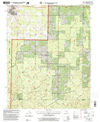
1997 Map of Birch Tree
USGS Topo · Published 1999About this map
Birch Tree serves as the primary settlement on this late 20th-century Ozark landscape, where the terrain is defined by a dense network of timbered ridges and deep drainage hollows. Much of the southern and central portion of the map is managed as part of the Mark Twain National Forest and the Birch Tree Conservation Area, reflecting the region's long-standing connection to forest management. The landscape is carved by several significant waterways, including Birch Creek and Hurricane Creek, alongside numerous named valleys like Grassy Hollow and Two Mule Hollow. Small-scale industry and infrastructure are noted through a Mine and a Lookout Tower, while the presence of the small community of Ranch and several scattered cemeteries suggests the area's rural social fabric. The transition from the Shannon Co Oregon Co border highlights the jurisdictional shifts in these highland woods.
Find a feature on this map
29 named features on this map. Tap any name to fly to it.
Don’t see what you’re looking for? This feature index may not catch every label — zoom into the map to look around manually.
Map Details
Editions of this 1997 Birch Tree Map
This is the sole edition of this map. No revisions or reprints were ever made.
Other maps of this area

1915 · Eminence
USGS Topo · 1:62,500

1917 · Eminence
USGS Topo · 1:62,500

1931 · Bandyville
USGS Topo · 1:48,000

1944 · Birch Tree
USGS Topo · 1:62,500

1945 · Montier
USGS Topo · 1:62,500

1946 · Summersville
USGS Topo · 1:62,500

1948 · Montier
USGS Topo · 1:62,500

1948 · Birch Tree
USGS Topo · 1:62,500

1948 · Summersville
USGS Topo · 1:62,500

1949 · Rolla
USGS Topo · 1:250,000