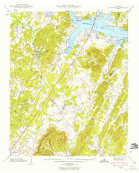
1942 Map of Birchwood
USGS Topo · Published 1960About this map
Chickamauga Lake and the Hiwassee River dominate the northeastern corner of this landscape, reflecting the Tennessee Valley Authority’s recent transformation of the river system during the early 1940s. The terrain transitions from the water's edge through the Knobs and Burdette Ridge toward the prominent Whiteoak Mountain in the south. This era shows a distributed rural society organized around small crossroads like Birchwood, Brittsville, and Georgetown, where local life centered on numerous country churches and schools.
Find a feature on this map
53 named features on this map. Tap any name to fly to it.
Don’t see what you’re looking for? This feature index may not catch every label — zoom into the map to look around manually.
Map Details
Editions of this 1942 Birchwood Map
This is the sole edition of this map. No revisions or reprints were ever made.
Other maps of this area

1886 · Cleveland
USGS Topo · 1:125,000

1888 · Chattanooga
USGS Topo · 1:125,000

1892 · Cleveland
USGS Topo · 1:125,000

1893 · Chattanooga
USGS Topo · 1:125,000

1895 · Cleveland
USGS Topo · 1:125,000

1901 · Cleveland
USGS Topo · 1:125,000

1935 · East Cleveland
USGS Topo · 1:24,000

1935 · Goodfield
USGS Topo · 1:24,000

1935 · Snow Hill
USGS Topo · 1:24,000

1935 · Charleston
USGS Topo · 1:24,000