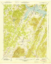
1943 Map of Birchwood
USGS Topo · Published 1943About this map
Chickamauga Reservoir and the Hiwassee River define the northern boundary of this survey, where the rising waters meet the foothills of White Oak Mountain. The landscape is a mix of small rural centers and family landmarks, with Georgetown and Birchwood serving as primary hubs for the surrounding farming community. Evidence of local history is scattered throughout the valleys, from the Mc Clanahan Cem near the riverbanks to the St Elmo Sch in the southern hills.
Find a feature on this map
61 named features on this map. Tap any name to fly to it.
Don’t see what you’re looking for? This feature index may not catch every label — zoom into the map to look around manually.
Map Details
Editions of this 1943 Birchwood Map
This is the sole edition of this map. No revisions or reprints were ever made.
Other maps of this area

1886 · Cleveland
USGS Topo · 1:125,000

1888 · Chattanooga
USGS Topo · 1:125,000

1892 · Cleveland
USGS Topo · 1:125,000

1893 · Chattanooga
USGS Topo · 1:125,000

1895 · Cleveland
USGS Topo · 1:125,000

1901 · Cleveland
USGS Topo · 1:125,000

1935 · East Cleveland
USGS Topo · 1:24,000

1935 · Goodfield
USGS Topo · 1:24,000

1935 · Snow Hill
USGS Topo · 1:24,000

1935 · Charleston
USGS Topo · 1:24,000