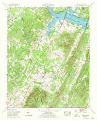
1967 Map of Birchwood
USGS Topo · Published 1970About this map
White Oak Mountain anchors the southern portion of this landscape, its ridges punctuated by landmarks like Tallaferro Gap and Bargen Knob. The terrain is defined by a series of parallel ridges and hollows, including Burdette Ridge and Humphreys Ridge, which channel the various branches of Gunstocker Creek toward the Hiwassee River. To the north, the waters of Chickamauga Lake spill into sloughs and branches, creating the habitat of the Hiwassee Wildlife Refuge near Jewell Bluff.
Find a feature on this map
78 named features on this map. Tap any name to fly to it.
Don’t see what you’re looking for? This feature index may not catch every label — zoom into the map to look around manually.
Map Details
Editions of this 1967 Birchwood Map
This is the sole edition of this map. No revisions or reprints were ever made.
Other maps of this area

1886 · Cleveland
USGS Topo · 1:125,000

1888 · Chattanooga
USGS Topo · 1:125,000

1892 · Cleveland
USGS Topo · 1:125,000

1893 · Chattanooga
USGS Topo · 1:125,000

1895 · Cleveland
USGS Topo · 1:125,000

1901 · Cleveland
USGS Topo · 1:125,000

1935 · East Cleveland
USGS Topo · 1:24,000

1935 · Goodfield
USGS Topo · 1:24,000

1935 · Snow Hill
USGS Topo · 1:24,000

1935 · Charleston
USGS Topo · 1:24,000