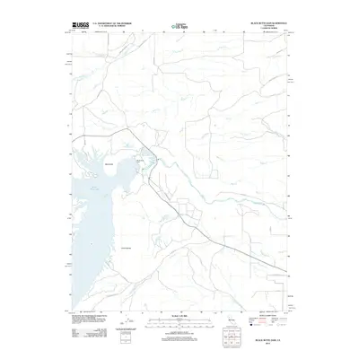
2012 Map of Black Butte Dam
USGS Topo · Published 2012About this map
Black Butte Lake and the Black Butte Dam dominate this Central Valley landscape, regulating the flow of Stony Cr as it exits the eastern foothills. The topography is defined by the prominent Black Butte and the elongated Orland Buttes, which flank the reservoir's southern reaches. This 2012 survey illustrates the hydrological network that sustains the region's agricultural character, with numerous named waterways such as Rice Cr, Hambright Cr, and Brannin Cr dissecting the terrain.
Find a feature on this map
35 named features on this map. Tap any name to fly to it.
Don’t see what you’re looking for? This feature index may not catch every label — zoom into the map to look around manually.
Map Details
Editions of this 2012 Black Butte Dam Map
This is the sole edition of this map. No revisions or reprints were ever made.
Other maps of this area

1904 · Vina
USGS Topo · 1:62,500

1904 · Walker Creek
USGS Topo · 1:31,680

1906 · Willows
USGS Topo · 1:62,500

1914 · Kirkwood
USGS Topo · 1:31,680

1914 · Orland
USGS Topo · 1:31,680

1919 · Fruto
USGS Topo · 1:62,500

1944 · Fruto
USGS Topo · 1:62,500

1944 · Flournoy
USGS Topo · 1:62,500
1949 · Kirkwood
USGS Topo · 1:24,000
1950 · Kirkwood
USGS Topo · 1:24,000