1904 Map of Vina
USGS Topo · Published 1904About this map
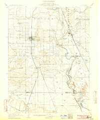
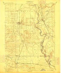
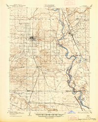
The Sacramento River meanders through the heart of this Sacramento Valley landscape, shaping the agriculture and transport of Tehama, Butte, and Glenn counties. At Vina, a prominent Winery stands near the Southern Pacific RR (Shasta Route), reflecting the region’s early viticulture. The river itself is a bustling corridor of commerce, marked by numerous named bends and landings such as Merrill's Landing and Mc Intosh Landing.
Find a feature on this map
62 named features on this map. Tap any name to fly to it.
Don’t see what you’re looking for? This feature index may not catch every label — zoom into the map to look around manually.
Map Details
Editions of this 1904 Vina Map
3 editions found
Other maps of this area

1886 · Lassen Peak
USGS Topo · 1:250,000

1890 · Red Bluff
USGS Topo · 1:250,000

1891 · Chico
USGS Topo · 1:125,000

1892 · Lassen Peak
USGS Topo · 1:250,000

1893 · Chico
USGS Topo · 1:125,000

1894 · Lassen Peak
USGS Topo · 1:250,000

1894 · Red Bluff
USGS Topo · 1:250,000

1895 · Chico
USGS Topo · 1:125,000

1904 · Walker Creek
USGS Topo · 1:31,680
1905 · Tehama
USGS Topo · 1:62,500