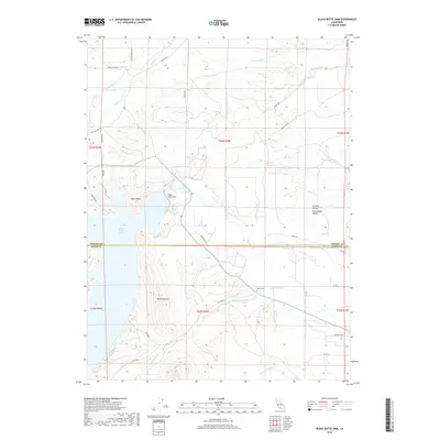
2018 Map of Black Butte Dam
USGS Topo · Published 2018About this map
Stony Creek flows through the center of this landscape, its waters controlled by the Black Butte Dam to form the expansive Black Butte Lake. This 2018 survey captures the interface between the edge of the Sacramento Valley and the rising elevations of the Orland Buttes and the namesake Black Butte. The area is defined by its drainage network, with numerous named seasonal and perennial watercourses like Hambright Creek, Brannin Creek, and Sehorn Cr carving through the terrain.
Find a feature on this map
42 named features on this map. Tap any name to fly to it.
Don’t see what you’re looking for? This feature index may not catch every label — zoom into the map to look around manually.
Map Details
Editions of this 2018 Black Butte Dam Map
This is the sole edition of this map. No revisions or reprints were ever made.
Other maps of this area

1904 · Vina
USGS Topo · 1:62,500

1904 · Walker Creek
USGS Topo · 1:31,680

1906 · Willows
USGS Topo · 1:62,500

1914 · Kirkwood
USGS Topo · 1:31,680

1914 · Orland
USGS Topo · 1:31,680

1919 · Fruto
USGS Topo · 1:62,500

1944 · Fruto
USGS Topo · 1:62,500

1944 · Flournoy
USGS Topo · 1:62,500
1949 · Kirkwood
USGS Topo · 1:24,000
1950 · Kirkwood
USGS Topo · 1:24,000